-
ChicagoMittal, Vinky. "How Colonial-Era French Jesuits Mapped the Idea of India." Impart Perspectives, June 16, 2026. https://imp-art.org/perspectives/features/how-colonial-era-french-jesuits-mapped-the-idea-of-india/
-
MLAMittal, Vinky. "How Colonial-Era French Jesuits Mapped the Idea of India." Impart Perspectives, Jun. 16, 2026, https://imp-art.org/perspectives/features/how-colonial-era-french-jesuits-mapped-the-idea-of-india/. Accessed 16 Oct 2026.
-
HarvardMittal, V. (2026) How Colonial-Era French Jesuits Mapped the Idea of India, Impart Perspectives. Available at: https://imp-art.org/perspectives/features/how-colonial-era-french-jesuits-mapped-the-idea-of-india/ (Accessed: 16 October 2026).
How Colonial-Era French Jesuits Mapped the Idea of India
Studying the cartographic imaginaries advanced by the French Jesuits is crucial to understanding how they shaped regional identities in the Indian subcontinent through their work.
By Vinky Mittal
Link copied!
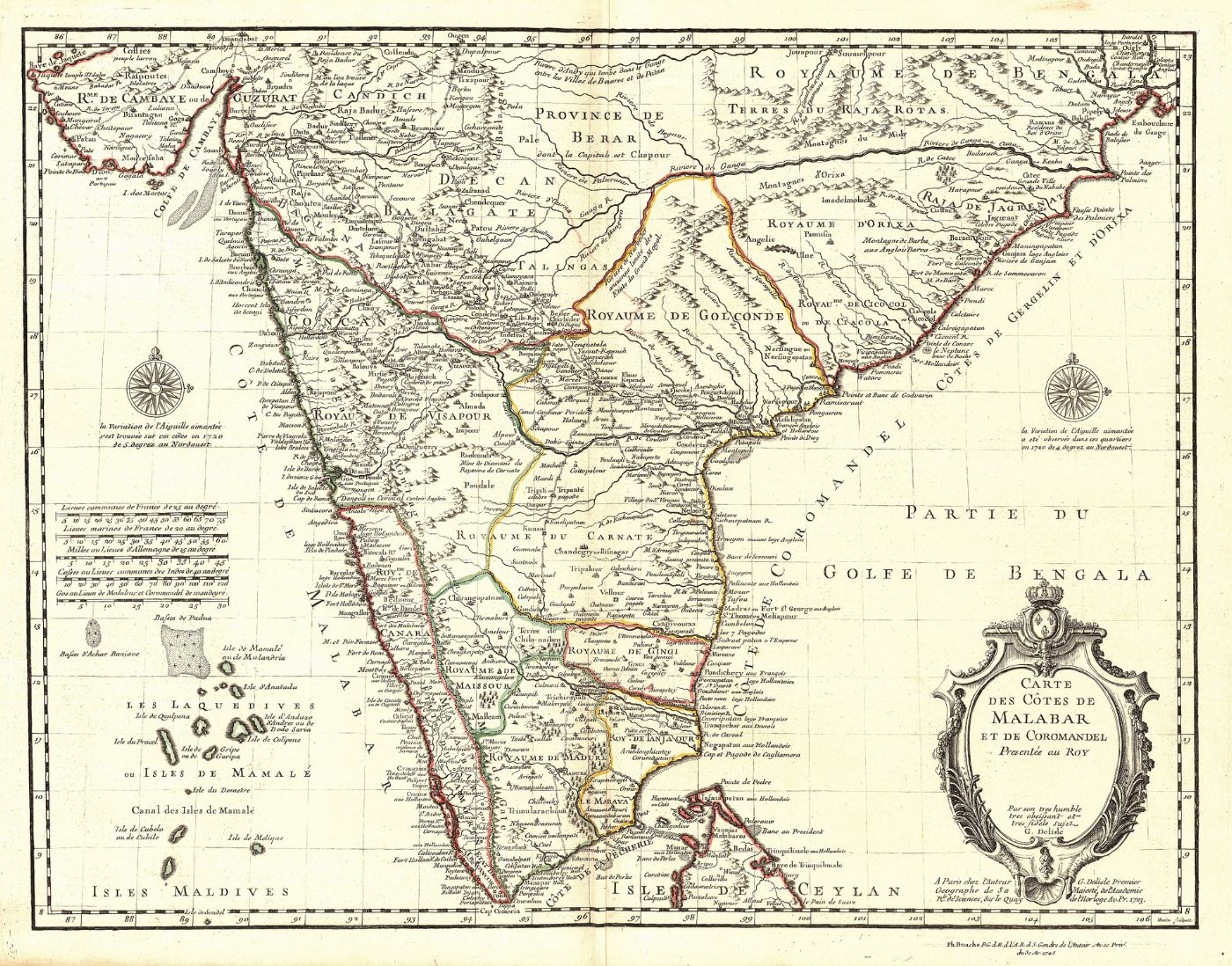
The Carte des Côtes de Malabar et de Coromandel map; Guillaume De Lisle; Paris, France; 1723; Publisher: Philippe Buache (The 1745 Atlas Noveau). Wikimedia Commons
The French monarchy officially acknowledged their imperial ambitions in the Indian subcontinent by setting up the French East India Company in 1664. With Portugal losing their monopoly and territorial influence, France wanted to compete with the growing dominance of British and Dutch traders in the region. This colonial endeavour was supported by French Jesuit missionaries associated with the Old Madurai Mission, established in 1606 under Portuguese patronage, and later, the Carnatic Mission, established by France in the early 18th century. Both were foundational Jesuit Catholic outreach movements based out of South India.
Entrusted with the evangelisation of Indians by France’s king, Louis XIV, and Francois Martin, the first Governor-General of French India, French Jesuit missionaries would maintain records and maps of Indian territories and send this information back to Paris by means of letters. Some of the prominent Jesuit writers and map makers included Jean-Venant Bouchet (1655–1732), Jean Richaud (1633–1693), Claude-Stanislas Boudier (1686– 1757), Jean-François Pons (1698–1753), Pierre Mauduit (1664–1711), Louis-Noël de Bourzes (1673–1735), Claude Moriset (1667–1742), and Gaston-Laurent Cœurdoux (1691–1779), among others. While only a few of them, such as Bouchet, de Bourzes, Moriset, and Boudier had the training to draw maps, the others would contribute by making observations and meticulously documenting their travels in their letters. The information sent back by them would help Paris replace Lisbon in Portugal, and even Rome, as centres of Catholic knowledge collection about India.
One major stumbling block that the missionaries faced was that their local Indian informants lacked a uniform standard for measuring distances. Not only did the ‘Indian mile’ not match the European one but the measurement of this distance (kos) also varied from region to region. French Jesuit cartographers in India would complain about not having all the required instruments to make accurate measurements, which meant that their notes on latitudes and longitudes were usually off by one to two degrees. But even then, their work was a vast improvement on earlier navigational maps that sometimes had deviations of up to twenty degrees and mainly concentrated on India’s coastal areas.
Jesuits were regarded as scholars and ‘Men of Science’ in Europe rather than just members of the Catholic clergy. Jesuit colleges in France equipped their missionaries with rigorous theological, linguistic, and scientific education, before they were deployed to places like New France (North America), Latin America, China, and India. Their ‘letter-reports’ were published between 1702 and 1776 and compiled into a 34-volume collection known as the Lettres édifiantes et curieuses (The Edifying and Curious Letters). Of these, volumes 10 to 15 covered the Indian subcontinent. Since these were some of the first detailed Western accounts by educated scholars about India, they were seen as highly reliable sources of information.
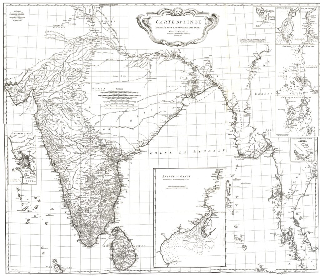
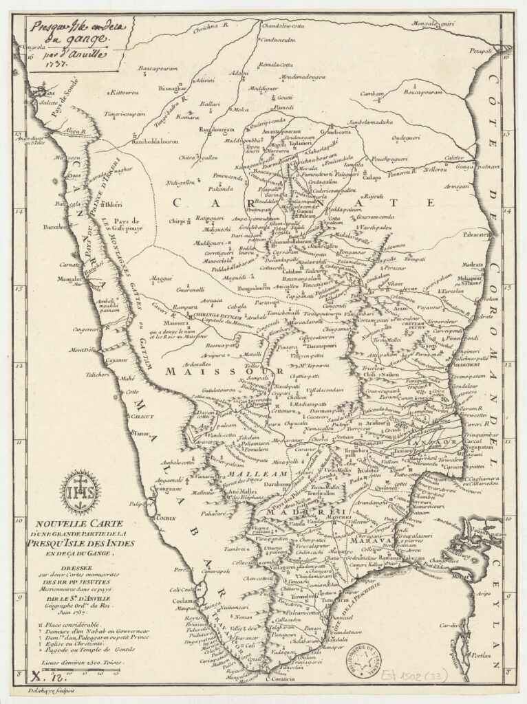
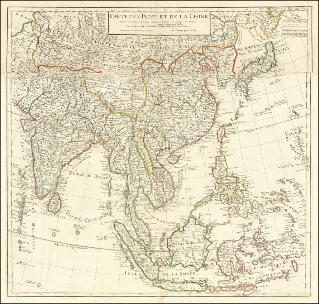
Professional cartographers in Paris and London, such as Jean-Baptiste Bourguignon d’Anville (1697–1782), Guillaume Delisle [also spelled “de L’Isle”] (1675–1726), and James Rennell (1742–1830), developed detailed composite maps of the interior regions of India based on the cartographic sketches and data sent by Bouchet and his fellow French Jesuits. For his 1737 map, titled Nouvelle carte d’une grande partie de la presqu’île des Indes en-deçà du Gange, and 1752 map, titled Carte de l’Inde, d’Anville drew on the information gathered by Father Xavier Duchamp (1693–1740), as well as the detailed travel itinerary of Boudier and Pons, when they travelled from Bengal’s Chandernagor, where a Jesuit outpost was located, all the way to Jaipur. Their notes contained the latitudes and longitudes of about 60 Indian towns and cities, along with topographical descriptions of the regions they crossed on their long journey to the court of the Raja of Amber, Sawai Jai Singh. Similarly, Delisle added many place names and territories in his map titled Carte des Cotes de Malabar et de Coromandel, published in the 1723 using Jean-Baptiste Tavernier and Mauduit’s travel accounts.
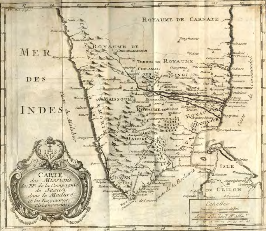
The establishment of the Académie des Sciences in 1666 and the Paris Observatory in 1667 saw France take the lead in Europe when it came to gathering scientific knowledge. Astronomers and cartographers would soon begin to rely on the active correspondence of France’s Jesuit missionaries for information and measurements from across the world. The French Carnatic Mission supplemented the maps they sent to Paris with extensive notes on Indian geography and its population, with details about territorial spaces, latitudes and longitudes, and local histories. One of the earliest maps of Southern India was published in 1722. It was based on a 1719 map sent by Bouchet to France and later attributed to the combined efforts of Bourzes and Moriset. It was remarkably detailed, showing the locations of major towns and residences of indigenous rulers, as well as natural topographical features of the region, such as rivers and mountains, including the Eastern Ghats.
Bouchet himself would traverse the Coromandel coast on foot to engage in astronomical observations and careful documentation to produce a number of maps and sketches of Madurai. He also spent a considerable amount of time writing about the river Ganges, including its geography and mythology. He not only described the river’s route but also its strategic importance to indigenous rulers and the growing presence of European traders in the region.
As the determination of latitudes and longitudes was extremely important for France’s commercial and political interests, the missionaries tried to record and verify these measurements wherever they went. For instance, Bouchet wrote in his notes: ‘Madras est à 13° V 8″ de latitude nord.’ Similarly, the 1719 map that Bouchet sent to France, which covered Madurai and its neighbouring kingdoms, extended up to ‘slightly north of latitude 14° N.’ Later, in 1734, Boudier would fix the coordinates of other major cities, such as Delhi, Jaipur, and Agra, with the help of French astronomer and Jesuit priest Antoine Gaubil (1689-1759), who was stationed in China.
Even though map coordinates can seem like neutral measurements, like any other knowledge production funded by European nations during this time, they privileged the Western viewpoint when it came to understanding the world. By locating the prime meridian in Paris, the longitudinal measurements fixed by French cartographers placed Europe at the centre of the world with Asia to the East and the Americas to its West. They also transformed the land into abstract coordinates that aided colonial powers in charting the most efficient navigable routes on land and over sea to launch trade and military campaigns, and later to impose fixed borders. Overall, the Jesuits’ documentation contributed to erasing indigenous ways of knowing the land.
Before the 1700s, the understanding of territorial limits of medieval kingdoms among the local populace on the subcontinent was fluid. Rulers fought over zones of influence centred around the control of trade routes and major trading hubs, and the right to collect taxes in populated areas. ‘Natural’ geographical features, such as a river or a mountain range, would often separate kingdoms. But even these borders were far from fixed as they were not bound by mapped coordinates. Mughal war campaigns in the prosperous Deccan region from Akbar’s reign onwards to Aurangzeb’s death in 1707 saw kingdoms and dominions rise and fall. There were also massive regional shifts in power in Southern India between the 15th and 17th centuries. The most striking one, of course, was the collapse of the Vijayanagara empire after the 1565 Battle of Talikota, and the subsequent rise of the Nayaka kingdoms, run by the nayakas (military governors) of the fallen empire.
Therefore, the native population’s connection to their land was more strongly linked to ancestral histories and local caste and community ties. Language, dialects, and family lineages played a far more important role in the formation of indigenous identities. All of these were cultural or social markers, not geographical ones. But the intersection between geography and socio-cultural identities was a key feature of Jesuit documentation since they were keen to understand the people living within the territories they were mapping. This created narratives about the subcontinent linked to oral histories collected and analysed by the Jesuit missionaries and their own observations about the native populace. Such observations, unsurprisingly, were deeply influenced by the institutional views of their Order, the Society of Jesus, and also the Catholic Church.
Muslim rulers were seen as religious adversaries because of the lingering memories of the ultimately unsuccessful Crusades. Even the politically prudent Franco-Ottoman alliance was seen as a Machiavellian deal struck with the ‘infidel’ Muslim Turks. The alliance coexisted, rather paradoxically, with popular crusading attitudes among the clergy and general populace in Catholic France.
One of the chief motives for the Jesuit letters sent to France was to attract funds for the Order’s Missions. They were propagandistic by nature and served the expectations of the French reading public. In this sense, they were not neutral scholarly accounts.
For instance, Mauduit, based out of Pondicherry, would call for Jesuit missionaries to be dispatched to the land in even greater numbers to convert idolaters, ‘lest the Mohammedans, who get possession of all these countries [Indian kingdoms] by insensible degrees, should force the inhabitants of them to embrace their abominable religion.’ The French saw the expanse of the Indian subcontinent politically divided into two categories: the Mughal India of the North and the independent kingdoms (l’Inde pathane and l’Inde carnatic). Muslim rulers were described as invaders who had disrupted the order achieved by local rulers. Bouchet, one of the most prodigious letter writers from India, lamented the fate of ‘unfortunate’ local princes who had been tricked by the followers of ‘mahométisme’ (Mohammedanism aka Islam).
In other Jesuit accounts as well, territorial skirmishes were reimagined as civilisational clashes that pitted the ‘native’ Indian population against ‘invading’ Muslims. ‘Hindu’ as a pan-India identity had yet to take shape and Jesuit accounts would use terms like ‘Gentiles’, ‘Heathens’, ‘Idolaters’, and ‘Pagans’ to describe them or refer to them as ‘Indians’ or by their caste or community names, such as ‘Bramins‘, (Brahmins) ‘Shootres’ (Shudras), and ‘Parias’ (‘untouchable’ castes).
Bouchet would compare Indians in pre-Islamic India to ‘ancient Christians.’ He argued that the original, essential nature of religion in ‘classical’ India was monotheistic but had devolved over centuries into the ‘errors of idolatry’. The fate of the Indians was seen as a cautionary tale — something that could happen in France if ‘inferior races’ altered the course of French culture. Another French Jesuit priest, Peter de la Lane, would note Indians worshiped ‘strange gods’, but that it was evident that they once had ‘knowledge of the true God.’
Bouchet made a case that Indians had originally ‘borrowed’ their religion from the ‘Books of Moses and the Prophets’, comparing Indian mythological figures and events to Biblical stories in the Old Testament about Noah, Abraham, and Moses. He would also link Jewish religious customs to caste-based ‘purity’ practices, such as eating only certain types of food, and strictly marrying within caste. Indian theological and scientific texts were all interpreted using Eurocentric and Christian frames of reference to make a case for conversions or to deal with gaps in their knowledge while encountering, what was to them, profoundly alien forms of knowledge and cultural production. But, even though French Jesuits largely followed the policy of accommodatio (accommodations) for Brahminical culture and some missionaries even adopted a vegetarian diet to sway Brahmins into converting, Jesuit missionaries would continue to see followers of Islam as a threat.
Documenting his efforts at conversions, Bouchet would note: ‘The Preachers of the Gospel are frequently imprisoned, and otherwise abused, in their Mission; which is owing to the avidity of the Mohammedans, who… persecute ’em, from the natural aversion they bear to the Christian Name… The Indians are quite miserable, and reap very little benefit from their labours.’ Observations about the ‘Moors’ and ‘Mohammedans’ within the Jesuit archive of letters reveal exactly why the narrative about the ‘corrupting’ Muslim influence spread in both South Asia and Europe. Kate Teltscher, in her book India Inscribed, points out that between the years 1700 and 1750, views about India and Indians in Europe were overwhelmingly shaped by the contents of these letters sent by French Jesuits.
Subsequently, the narrative about the ‘civilisational clash’ became a key theory used in colonial propaganda about Islam and Hinduism in the subcontinent. It continues to haunt South Asian politics even after the establishment of modern nation-states. Therefore, studying the cartographic imaginaries advanced by the French Jesuits is crucial to understanding the development and consolidation of national and linguistic identities in the subcontinent.
First published: June 16, 2026